Roman Empire 125.png
De Triple Performance

Dimensões desta antevisão: 721 × 599 píxeis. Outras resoluções: 289 × 240 píxeis | 578 × 480 píxeis | 924 × 768 píxeis | 1 232 × 1 024 píxeis | 2 186 × 1 817 píxeis.
Ficheiro original (2 186 × 1 817 píxeis, tamanho: 4,43 MB, tipo MIME: image/png)
| Localização da câmara | | Esta e outras imagens nas suas localizações em: OpenStreetMap |
|---|
Descrição do ficheiro
| Descrição |
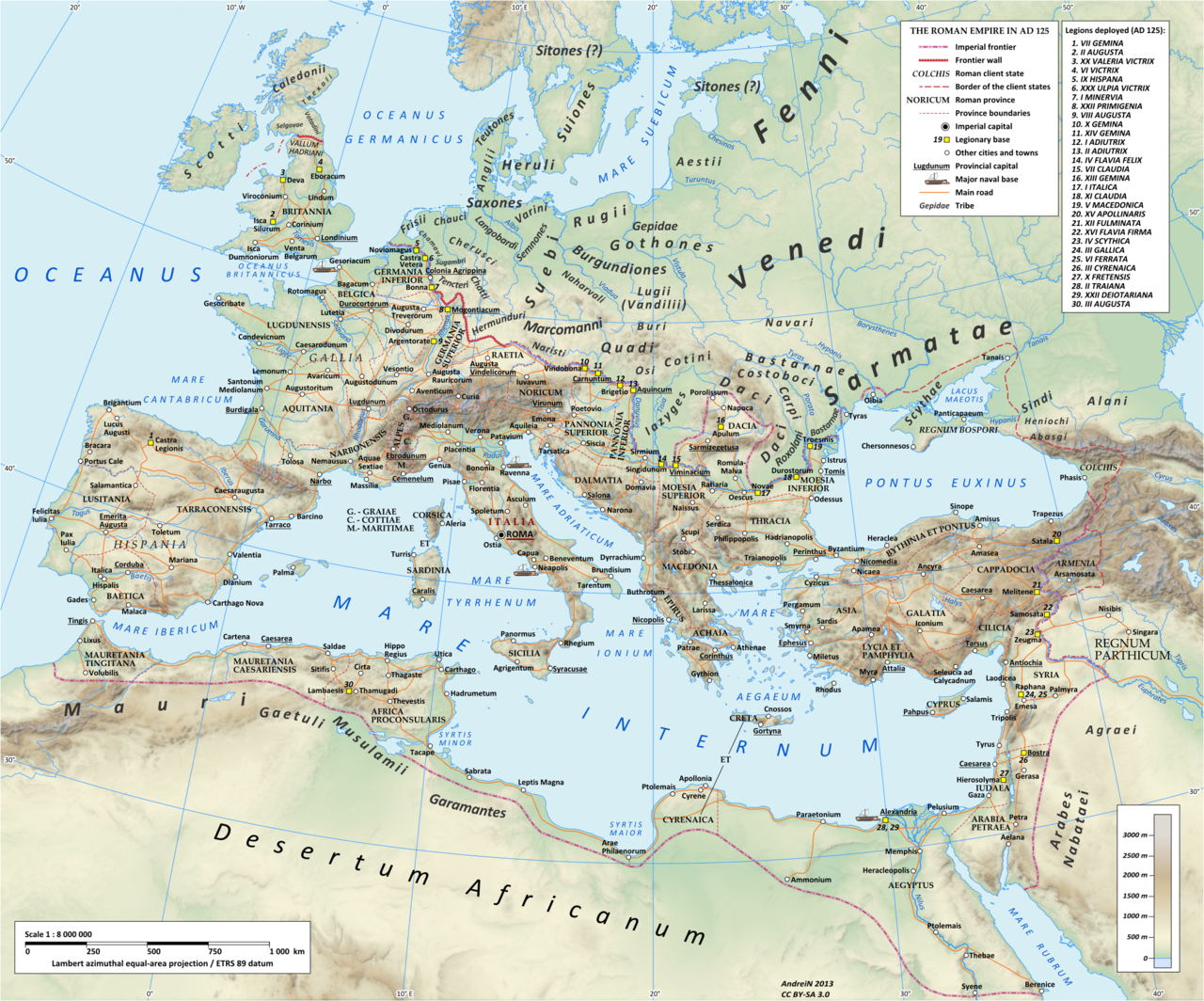
English: Map of the Roman Empire in 125 during the reign of emperor Hadrian, with anachronistic Germanic tribes from the time of Augustus.
Projection Lambert azimuthal-equal area. Central latitude: 45° N, central longitude: 20° E. X, Y origin offset - 0 Datum: ETRS89 Sources The physical map was made using the following public domain sources:
Additional references for the map content:
Software used GIS:
Graphics editors:
|
|||
| Data | ||||
| Origem | Obra do próprio | |||
| Autor | ||||
| Permissão (Reutilizar este ficheiro) |
Any use of this map can be made as long as you credit the author, Andrei N. (Wikipedia Commons user Andrein), and distribute the copies and derivative works under the same license as that the one stated below. | |||
| Outras versões |
[]
Similar maps: []
|
.png)


Licenciamento
Eu, titular dos direitos de autor desta obra, publico-a com as seguintes licenças:
A utilização deste ficheiro é regulada nos termos da licença Creative Commons - Atribuição-CompartilhaIgual 3.0 Não Adaptada.
- Pode:
- partilhar – copiar, distribuir e transmitir a obra
- recombinar – criar obras derivadas
- De acordo com as seguintes condições:
- atribuição – Tem de fazer a devida atribuição da autoria, fornecer uma hiperligação para a licença e indicar se foram feitas alterações. Pode fazê-lo de qualquer forma razoável, mas não de forma a sugerir que o licenciador o apoia ou subscreve o seu uso da obra.
- partilha nos termos da mesma licença – Se remisturar, transformar ou ampliar o conteúdo, tem de distribuir as suas contribuições com a mesma licença ou uma licença compatível com a original.

|
É concedida permissão para copiar, distribuir e/ou modificar este documento nos termos da Licença de Documentação Livre GNU, versão 1.2 ou qualquer versão posterior publicada pela Free Software Foundation; sem Secções Invariantes, sem textos de Capa e sem textos de Contra-Capa. É incluída uma cópia da licença na secção intitulada GNU Free Documentation License. |
Pode escolher a licença que quiser.
_en.png)
.png)
.jpg)
Histórico do ficheiro
Clique uma data e hora para ver o ficheiro tal como ele se encontrava nessa altura.
| Data/hora | Miniatura | Dimensões | Utilizador | Comentário | |
|---|---|---|---|---|---|
| atual | 19h34min de 12 de janeiro de 2019 | | 2 186 × 1 817 (4,43 MB) | wikimediacommons>ArdadN | This purpose of this map is not to represent ancient shorelines. Please upload a separate file with your original contributions! |
Utilização local do ficheiro
A seguinte página usa este ficheiro: